New Blue/Red Political Map of the United States
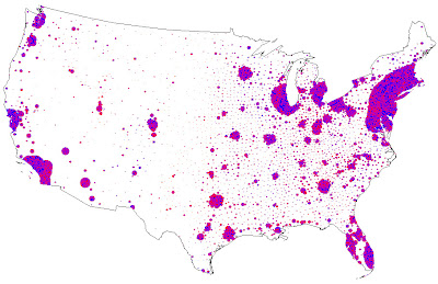
We have become very used to seeking maps showing Blue States (Democratic leaning) and Red States (Republican leaning). The map below takes this one step further by drilling down to more detailed populations and taking actual population into account. the map shows that the political geography of the united States is far more complicated than we have been lead to believe. Note in particular the urban versus suburban versus rural dynamic:
I found it here. Hat tip to Bradford Long.

I found it here. Hat tip to Bradford Long.

Comments